The surveying profession has a rich history. Dating back to the ancient world, Egyptians used a system of measurement based on human anatomy—the length of their arms, palms and fingers—to build one of the Seven Wonders of the Ancient World: The Great Pyramid of Giza. In the 18th and 19th centuries, surveyors were on the front line of exploring the Americas, using compasses, measurement chains, rulers and protractors to map the New Frontier.
Land surveying has been—and still is—essential to the world around us. Using logic, mapping and legal principles, surveyors measure, map and model the natural and built environment. In the architecture, engineering and construction industry, that data is used for numerous applications, such as new homes, highways, hospitals and high-rises, ultimately enabling designers to create communities where people can enjoy living, working and playing.
As the role of surveyors has evolved, so has the technology we use. A profession that once relied on finger lengths now utilizes lasers, drones, GPS satellites and robots to collect and process spatial data. While simple methods are still effective, and you can use a measuring tape or camera to model a single room in your house, surveying becomes increasingly complex as a project’s size increases, and new technologies enable us to create more efficient, effective models.
The advances in surveying technologies are creating positive disruptions, allowing a more seamless flow of data between the real and virtual worlds. That transition, combined with more accurate boundaries and surfaces, properly georeferenced machine control, and the Internet of Things, are enabling surveyors to precisely map land within a fraction of an inch. In honor of National Surveyors Week, I’m highlighting how modern surveying equipment is enabling our survey team at Gresham Smith to collect site data that leads to better projects.
Leaning in to LiDAR
Cell phones, tablets and measuring tapes aren’t up to the task when it comes to producing positionally accurate, three-dimensional maps of large sites. Topographic surveys use data to produce a three-dimensional map showing the configuration of the terrain and the location of natural features, such as rivers and hills, as well as man-made features, such as highways and houses. Topographic surveys often utilize Light Detection and Ranging technology (LiDAR), a unique remote sensing technology that has taken the surveying industry by storm.
LiDAR uses light, in the form of lasers, to measure distances. When a surveyor points a laser at a target, the laser is reflected back to the LiDAR equipment. The sensor records how long it takes for the light to bounce back from the target, and uses that information to determine the target’s distance. This data is then combined with the position and orientation of the LiDAR equipment, which is measured using GPS, to create a three-dimensional set of spatial coordinates that include latitude, longitude and height. This combination of data is called a point. LiDAR equipment collects countless points—some systems even collecting a million points per second—and creates a collection of points called a “point cloud.” Point clouds serve as the “middle man” in LiDAR surveying, turning the raw data into a 3D model.
In addition to measuring points and developing a 3D model, a professional surveyor will also establish permanent or semi-permanent control points so that the same surface can be reproduced in the same location during future surveys. This allows designers to compare newly constructed projects to their original design renderings.
Taking it to the Skies
Drone sUAS (small Unmanned Aircraft Systems), often simply called “drones,” continue to be recognized as powerful tools, and the surveying industry is no exception. Drones are making the process more efficient than ever before and are an integral part of the surveyor’s toolkit. Cameras or LiDAR hardware can be mounted on drones that are equipped with real-time kinematic GPS receivers to quickly collect enough data to produce a 3D surface model of large areas. Proper ground control is vital to the survey’s accuracy, but when done properly, the measurements are precise within inches for photogrammetry and a fraction of an inch for LiDAR.
The images below represent some of the surfaces generated by photogrammetry.

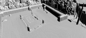
Notice how the cars, trees and brush produce “noise” on the surface. Computer software can generate contours from datasets that represent a space called point clouds (shown above) for ease of three-dimensional representation on two-dimensional maps. The examples above only utilized images taken vertically, but if detail on the sides of buildings is desired, then oblique imagery can be used.
A Smart Solution
There are numerous benefits to using LiDAR surveying for 3D site mapping. Two of the biggest advantages are LiDAR’s ability to map a variety of locations, including hard to reach areas (such as high mountains) and its ability see thorough dense vegetation (such as forest canopies). In addition, LiDAR isn’t affected by geometrical distortions like angular landscapes, and the largely automated process requires minimal human involvement.
Unlike photogrammetry, a survey method that uses aerial photographs to gather data, LiDAR surveying can operate in any light condition, which offers flexibility for survey crews. While photogrammetry produces a real-world visual representation similar to Google Street View, the same effect can be achieved with LiDAR by combining the surface model with oblique imagery.
Looking to the Future
While land surveying has been around for thousands of years, the profession has never waned in importance. With land values at all-time highs and an eye on sustainable building practices, efficiently and effectively gathering site information is key for successful projects. Modern technologies such as LiDAR and drones are propelling the industry forward, and by marrying new equipment with specialized technical skills, logic and intuition, surveyors are setting the foundation for the future. Every project starts and ends with a surveyor’s logic. Ultimately, professional surveyors serve as trained liaisons between the physical world and the mathematical world. From the roads that connect us to the offices where we work and the buildings we live in, surveyors are the foundation for improving the cities and towns we call home.